GrenobleFuté: Difference between revisions
Jump to navigation
Jump to search
No edit summary |
|||
| (44 intermediate revisions by the same user not shown) | |||
| Line 1: | Line 1: | ||
=Project presentation= |
=Project presentation= |
||
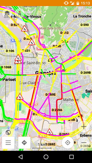
[[File:Screenshot_app.png|300px|thumb|Application screenshot]] |
|||
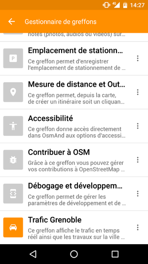
[[File:Screenshot_greffons.png|300px|thumb|Managers plugins screenshot]] |
|||
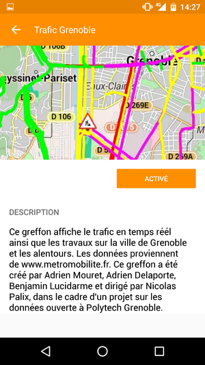
[[File:Screenshot_plugin.png|300px|thumb|Plugin activation screenshot]] |
|||
=Team= |
=Team= |
||
| Line 8: | Line 12: | ||
=Links= |
=Links= |
||
*Github : https://github.com/Lucidarme/Osmand.git |
|||
*Github : |
|||
=Progress of the project= |
=Progress of the project= |
||
==''Week 1 (January 11th - January 17th)''== |
==''Week 1 (January 11th - January 17th)''== |
||
Choice of the |
Choice of the subject |
||
==''Week 2 (January 18th - January 24th)''== |
==''Week 2 (January 18th - January 24th)''== |
||
*Installation |
*Installation of the various tools required for application development : |
||
** JAVA 1.8 |
** JAVA 1.8 |
||
** SDK Android API 15 |
** SDK Android API 15 |
||
** Cordova |
|||
* |
*Creation of the git |
||
* |
*Thinking about tools to use to develop the application: Cordova or native code |
||
*Project outlook : |
|||
*Perspectives du projet : |
|||
** Cordova => |
** Cordova => find a target (« only » display the map is useless) |
||
** |
** Native code => OSMand gives the possibility of routing thereafter |
||
** Conclusion : |
** Conclusion : Find an interesting extension to Cordova or do native code |
||
*Requirements |
|||
**Functional requirements: |
|||
***Viewing the traffic on a Grenoble map |
|||
***Update in real time |
|||
***Non-functional requirements: |
|||
***Network quality |
|||
***Reliability |
|||
***Updating the map of Grenoble |
|||
***Ergonomic |
|||
==''Week 3 (January 25th - January 31th)''== |
==''Week 3 (January 25th - January 31th)''== |
||
Reading / understanding the code |
|||
==''Week 4 (February 1st - February 7th)''== |
==''Week 4 (February 1st - February 7th)''== |
||
*Reflexion about the libraries available in JAVA to carry the parser JSON.org, JACKSON |
|||
*Viewing text when activating the plugin (detection where to write the plugin code) |
|||
| ⚫ | |||
*Choice of the library : JACKSON |
|||
*Realization of an application in stand-alone |
|||
*Link to SkiMapPlugin to test |
|||
*Goal : direct link to our plugin |
|||
| ⚫ | |||
===Design pattern=== |
===Design pattern=== |
||
* Adapter : |
* Adapter : Using data / external applications : métromobilités & OSMand data |
||
* Memento : |
* Memento : Restoration of the application if we remove the plugin |
||
* Observer : |
* Observer : To change its state, the map must be informed of the change of traffic data |
||
* MVC : model view controller architecture to separate the representation of the map and data |
|||
* MVC : Architecture modèle vue contrôleur pour séparer la représentation de la carte et les données |
|||
==''Week 6 (February 29st - March 6th)''== |
|||
*Beginning of parser adaptation for the project |
|||
*Bug resolution to redirect to our plugin |
|||
==''Week 7 (March 7th - March 13th)''== |
|||
*Bug rezolution: the link to the plugin is effective |
|||
*We now can change the color of a route |
|||
==''Week 8 (March 14th - March 20th)''== |
|||
*Progress in the parser |
|||
==''Week 9 (March 21th - March 27th)''== |
|||
*Parser finished in JAVA, to integrate Android Studio |
|||
*Search the GPS code and other plugins to find how to change the color of a section of road |
|||
==''Week 10 (March 28th - April 3rd)''== |
|||
*XML parser implemented, integrated into Android Studio |
|||
*Creation of the Traffic Layer class that will be used to draw the road sections along the lines of class GPXLayer and DistanceCalculatorPlugin |
|||
==''Week 11 (April 4th - April 10th)''== |
|||
*Change of librairies for JSON parser for integration in Android Studio: using JSON.org |
|||
*Integration of XML parser in Android Studio: use of DOM and SAX libraries |
|||
*Link with the plugin manager to enable or disable the plugin |
|||
*Creation of the report, flyer and slides |
|||
Latest revision as of 13:45, 6 April 2016
Project presentation
Team
- Supervisor : Nicolas Palix
- Members : Delaporte Adrien / Lucidarme Benjamin / Mouret Adrien
- Department : RICM4
Links
Progress of the project
Week 1 (January 11th - January 17th)
Choice of the subject
Week 2 (January 18th - January 24th)
- Installation of the various tools required for application development :
- JAVA 1.8
- SDK Android API 15
- Creation of the git
- Thinking about tools to use to develop the application: Cordova or native code
- Project outlook :
- Cordova => find a target (« only » display the map is useless)
- Native code => OSMand gives the possibility of routing thereafter
- Conclusion : Find an interesting extension to Cordova or do native code
- Requirements
- Functional requirements:
- Viewing the traffic on a Grenoble map
- Update in real time
- Non-functional requirements:
- Network quality
- Reliability
- Updating the map of Grenoble
- Ergonomic
- Functional requirements:
Week 3 (January 25th - January 31th)
Reading / understanding the code
Week 4 (February 1st - February 7th)
- Reflexion about the libraries available in JAVA to carry the parser JSON.org, JACKSON
- Viewing text when activating the plugin (detection where to write the plugin code)
Week 5 (February 8st - February 14th)
- Choice of the library : JACKSON
- Realization of an application in stand-alone
- Link to SkiMapPlugin to test
- Goal : direct link to our plugin
Design pattern
- Adapter : Using data / external applications : métromobilités & OSMand data
- Memento : Restoration of the application if we remove the plugin
- Observer : To change its state, the map must be informed of the change of traffic data
- MVC : model view controller architecture to separate the representation of the map and data
Week 6 (February 29st - March 6th)
- Beginning of parser adaptation for the project
- Bug resolution to redirect to our plugin
Week 7 (March 7th - March 13th)
- Bug rezolution: the link to the plugin is effective
- We now can change the color of a route
Week 8 (March 14th - March 20th)
- Progress in the parser
Week 9 (March 21th - March 27th)
- Parser finished in JAVA, to integrate Android Studio
- Search the GPS code and other plugins to find how to change the color of a section of road
Week 10 (March 28th - April 3rd)
- XML parser implemented, integrated into Android Studio
- Creation of the Traffic Layer class that will be used to draw the road sections along the lines of class GPXLayer and DistanceCalculatorPlugin
Week 11 (April 4th - April 10th)
- Change of librairies for JSON parser for integration in Android Studio: using JSON.org
- Integration of XML parser in Android Studio: use of DOM and SAX libraries
- Link with the plugin manager to enable or disable the plugin
- Creation of the report, flyer and slides


